TRAIL FACTSHEET: TRAIL OF HEADLANDS | LAGOA
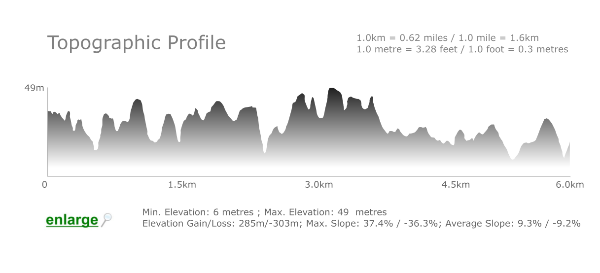
Location: Coastline between Praia do Paraíso, Carvoeiro (in the east) and Praia do Molhe, Ferragudo (in the west), Lagoa Municipality, Western Algarve | Coordinates: Praia do Paraíso: 37.096976 N, -8.474910 W; Praia do Molhe: 37.110069 N, -8.519072 W (decimal degrees) | Grade: Medium difficulty; Some steep stretches are difficult | Type: Linear Trail (Out & Back); Signposted trail | Length: 12-13 kilometres (up to 8.1 miles), there and back | Average Completion Time: up to 4-5 hours | Best Time to Visit: all year-round, except on hot, windy or rainy days | Activities: birding; nature walks; sightseeing.
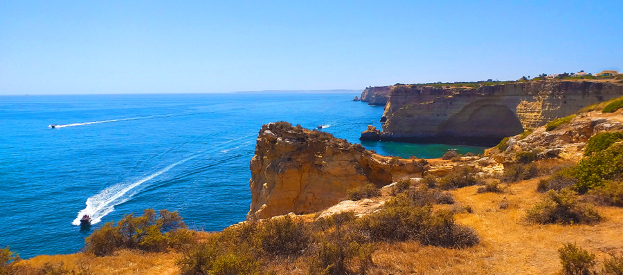
Some of these beaches are only accessible from the ocean by boat or kayak, but a few of them can be accessed through the narrow valleys that run perpendicular to the coast. From Carvoeiro, the stoney trail starts at the side of the restaurant located on the headland rising above Paraíso Beach and ends at Praia do Molhe in quaint Ferragudo. There are small car parks at both extremes of the trail. When the atmosphere is clear, from the various headlands it is possible to see the shoreline all the way to Sagres, which is located more than 40 kilometres to the west as the crow flies.
 Indeed, there are playful Crows inhabiting in the vicinity of the cliffs, as well as an abundance of warblers and marine birds. Along the way, there’s also a 16th century watchtower called Torre da Lapa that served as a base for sentinels guarding this jagged coastline. Centuries ago, pirates from North Africa often raided the Algarvian coast to abduct people and to loot the fishing villages, and the squat watchtower was part of a much larger defensive system designed to protect the once-insulated region.
Rising in front of Praia do Torrado (please check map), there’s a large sea stack called Leixão da Gaivota which serves as a crucially important nesting site for Cattle Egrets and Little Egrets; in fact, during spring this Special Protection Zone is crowned by countless white dots, each one of them a different egret on its nest. Binoculars (or similar equipment) are necessary to appreciate the abundant birdlife, which also includes species like Pallid Swift, Great Cormorant (in autumn and winter), Rock Dove and Alpine Swift, among others.
The jagged coastline contains a diversity of marine habitats, ranging from sandy coves and sea stacks to reefs and seagrass patches inhabited by many different species of fish, crab, anemone and starfish. A variety of Mediterranean scrubland plants, as well as orchids (during springtime) cover the tops of the cliffs. The trail is very uneven, and some stretches are rather steep and covered with loose rocks and pebbles. Care must be taken at all times. Keep a safe distance from the edges of the cliffs and sinkholes, as they can be unstable or slippery. For some visitors, this can be a challenging hike but seats affording scenic views are available throughout the trail, though. Bring plenty of water, sunscreen, a little food and sturdy shoes and, preferably, leave early in the morning to avoid hiking during the hottest hours of the day.
The trail can be walked in either direction using the markings (see here) painted on rocks and on posts along the way. Sturdy and adequate footwear is necessary for a comfortable walk. There are car parks at both ends of the trail. Access points at Ponta do Altar and at Caneiros Beach also allow a phased visit to each of the segments of the walk. Cafés are available at Pintadinho, Molhe, and Caneiros beaches, but they might be closed during low season. Enjoy!