TRAIL FACTSHEET
BIRDS & NATURE | TELHEIRO: PLEASE SEE HERE
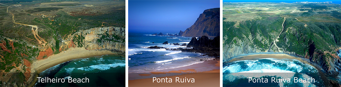
Location: Praia do Telheiro, Vila do Bispo; Vila do Bispo municipality; GPS Coordinates : 37°01’43.3″N 8°59’15.8″W (decimal degrees);
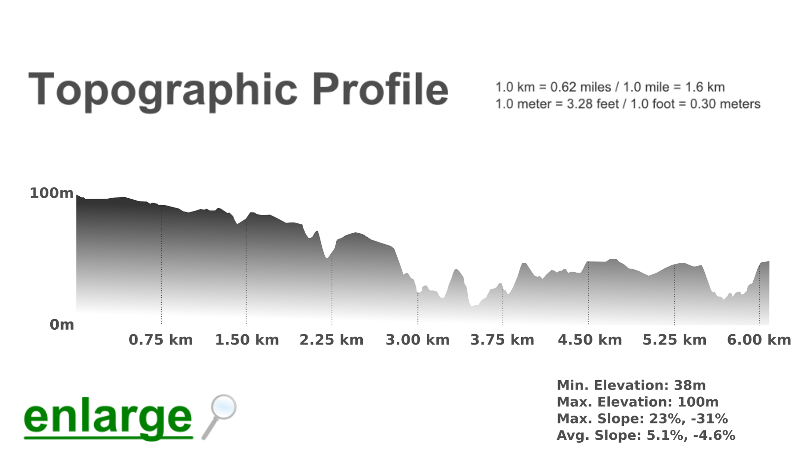
37.028683, -8.987735; Grade: difficult; Type: linear trail; this trail is not signposted; Lenght: 6200 meters/ 3.85 miles; Average Completion Time: up to 3 hours; Best Time to Visit: all year round; may not be advisable on stormy days; Activities: nature walks and hikes; birdwatching;
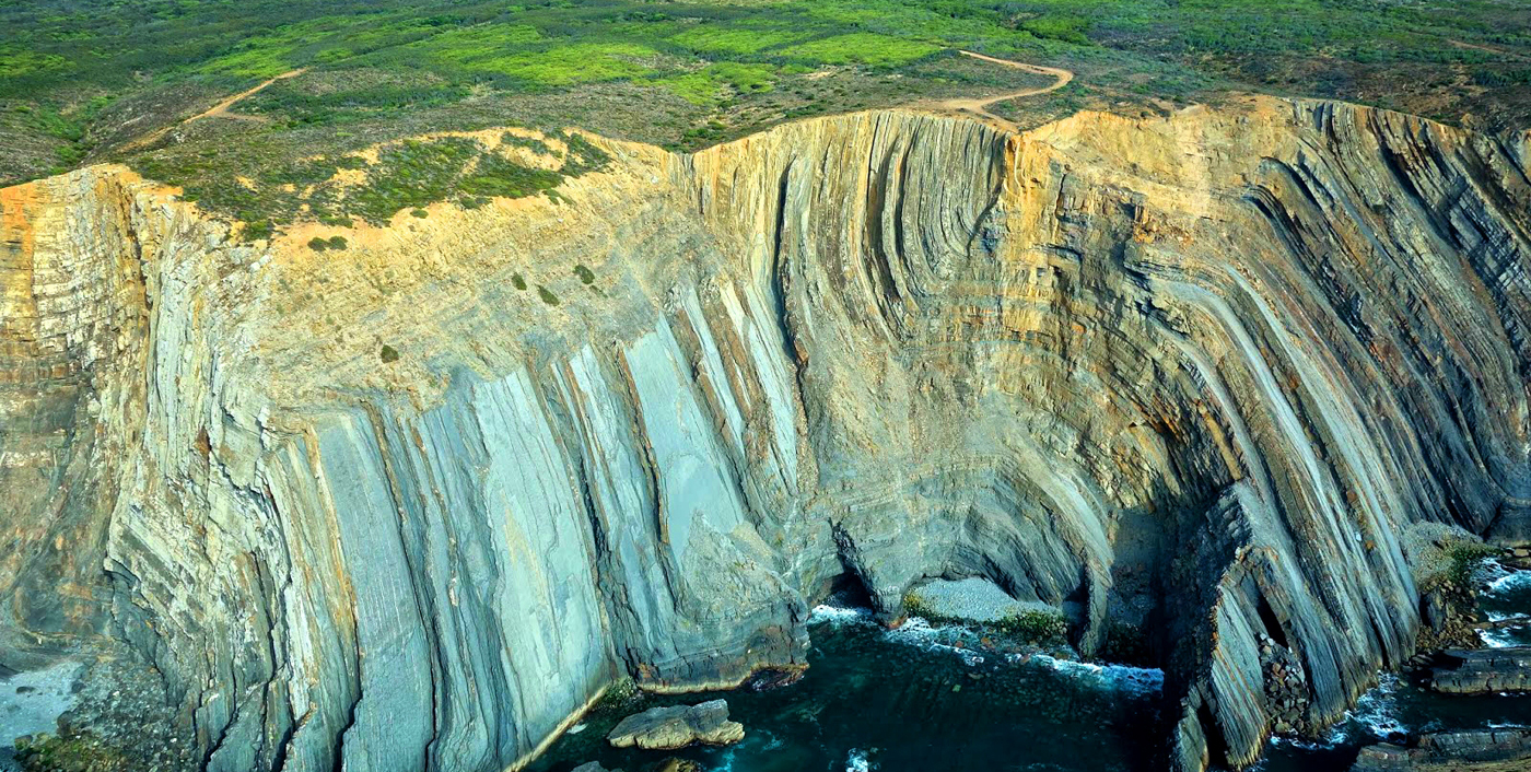
 Geologic ‘unconformities’ are abrupt, unexpected shifts between contiguous rock layers formed in very different periods (and under quite distinct conditions). In Telheiro, the once horizontal rock layers at the bottom of the cliff have been bent into an inverted “V” shape due to colossal tectonic forces. Then, a long time ago, these vertically folded shale layers were covered by a thick layer of horizontal Triassic sandstone.
Therefore, geologically, there is a conspicuous ‘time void’ of about 70 million years between these two consecutive rock layers. Such ‘time void’ can only be explained by the sheer erosion that affected the missing rock layers – these rocks have been utterly weathered away, erased into oblivion.
Why is this so important? Because it informs about the brutal geological shifts that occurred throughout the eons, their origins and their present-day consequences. Besides geology enthusiasts, interested parties may include seismologists, government agencies, oil companies and so on. This is indeed a site of special geologic significance and interest. Aerial images by A Terceira Dimensão
The contrast between the dark shale bottom and the reddish sandstone top is very dramatic and eye-catching. This rocky walk starts in the vicinity of Cape St. Vincent (please check map below) and ends near Praia da Ponta Ruiva Beach, making headway along cliffs whose elevation frequently goes above the 50 meters mark.
The scenery along cliff-tops and ravines is rugged and beautiful, but the walk is also quite rough and not at all suitable for everybody. Opposite the ocean, the landscape is dominated by farmland and austere grazing areas where several birds of prey go about their hunting.
Kestrels and Peregrine Falcons are relatively common sights; Warblers populate the coastal bushes, and there’s always the chance to observe Red-billed Choughs, Zitting Cisticolas, and Southern Grey Shrikes.
Praia do Telheiro itself is enclosed within a rocky bay offering a dramatic panorama to visitors; here, the rough seas pounding the stony inlet are not for the unfit or the too young. Jagged, daunting cliffs enfold a large sandy strip that is most frequently deserted, even during peak season.
This secluded beach is a great surfing spot, though – if any, the few other human beings around will probably be die-hard surfers. In winter, the beach’s ambiance conveys primeval feelings of remoteness and wildness.
Stopping in Telheiro, or proceeding on to Ponta Ruiva Beach, provides visitors the perfect chance to contemplate the great forces of nature in a raw, untamed state.
At Telheiro Beach, you will find yourself in awe as you stand on the threshold of time, experiencing the story of Iberia’s bygone eras in a way that cannot be found anywhere else in Portugal.
Finally, there is a footpath down to the beach, which is fairly difficult to negotiate. When at the beach, beware of loose rocks falling from above: please do not walk close to the base of the cliffs. Also, the edges of the cliffs are notoriously unstable – please refrain from getting too close to their boundaries. Low tide is the best time to observe the angular unconformity up close. The beach has no basic support facilities, nor any sort of supervision throughout the year. There are several tourist operators making this route, including Atalaia and Rota Vicentina.